Note: This is a project under development. The articles on this wiki are just being initiated and broadly incomplete. You can Help creating new pages.
File:Couroupita guianensis MHNT.BOT.2008.1.23.jpg

Size of this preview: 680 × 600 pixels. Other resolutions: 272 × 240 pixels | 544 × 480 pixels | 871 × 768 pixels | 1,161 × 1,024 pixels | 3,822 × 3,372 pixels.
Original file (3,822 × 3,372 pixels, file size: 7.94 MB, MIME type: image/jpeg)
Summary
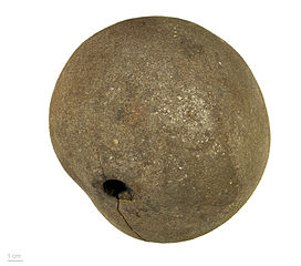
Focus stacking of 5 pictures.
|
Couroupita guianensis Aubl.,1775 |
| Photographer | ||||||||||||||||||||||||
| Description |
|
|||||||||||||||||||||||
| Place of discovery | Deutsch: Provenienz : Peru. English: Provenance : Peru. Français : Provenance : Pérou. |
|||||||||||||||||||||||
| Date | 21 March 2014 | |||||||||||||||||||||||
| Collection |
|
|||||||||||||||||||||||
| Accession number |
MHNT.BOT.2008.1.23 |
|||||||||||||||||||||||
| Source | Own work | |||||||||||||||||||||||
| Permission (Reusing this file) |
I, the copyright holder of this work, hereby publish it under the following license: This file is licensed under the Creative Commons Attribution-Share Alike 3.0 Unported license.
|
|||||||||||||||||||||||

| Camera location | | View this and other nearby images on: OpenStreetMap |
|---|

|
This document was made as part of the Projet Phoebus.
|

|
This image has been assessed under the valued image criteria and is considered the most valued image on Commons within the scope: Couroupita guianensis (cannonball tree), fruits. You can see its nomination here. |
File history
Click on a date/time to view the file as it appeared at that time.
| Date/Time | Thumbnail | Dimensions | User | Comment | |
|---|---|---|---|---|---|
| current | 12:35, 28 March 2014 | | 3,822 × 3,372 (7.94 MB) | Ercé | {{Information |Description ={{en|1=x}} |Source ={{own}} |Author =Ercé |Date = |Permission = |other_versions = }} |
File usage
The following page links to this file: